A video explaining the Greater Metropolitan Manila Area Risk Analysis Project. The aim of the project is to give a clearer understanding of the: Flooding in the Pasig-Marikina river basin Severe winds associated tropical cyclones Damaging earthquakes from the West Valley Fault Continue Reading
Philippine Institute of Volcanology and Seismology (Phivolcs) and the Japan International Cooperation Agency (JICA) have launched a 12-point questionnaire for Philippine homeowners to assess the earthquake readiness of their house. Rappler have created an interactive quiz based at: How Safe is My House? Self-check for Earthquake Safety See a video of concrete hollow block house […] Continue Reading
Seismology in layman’s terms. As if the Philippines has enough to worry about with its own earthquakes, an earthquake in the Pacific Northwest will also affect Asia. The Really Big One: An earthquake will destroy a sizable portion of the coastal Northwest. The question is when. Continue Reading
PHIVOLCS and GMA News Online have downloadable copy of The Valley Fault System Atlas on scribd . The higher-resolution copy is available for free download from the PHIVOLCS website. There is also a set of downloadable PDF files at The National Disaster Risk Reduction and Management Council website. Continue Reading
This looks like a useful device for helping to earthquake proof your home: “The Seismolatch reacts to even the smallest seismic movement, including rolling, shaking, and jolting. Before any cabinet door would open, the latch activates and secures the door.” http://seismolatch.com I wonder if there will soon be a Philippine-based supplier. Continue Reading
Prepare Manila will be holding a presentation giving an overview of the Metro Manila Earthquake Impact Reduction Study (MMEIRS) and how an earthquake may affect you. We will focus on why you should start preparing and hold an open forum to swap tips and share experiences.
Intended audience: the general public, preppers and emergency managers.
Time: Thursday, September 29 · 6:00pm - 9:00pm
Location: Manila Tytana Colleges, Metropolitan Park, Pres. Diosdado Macapagal Blvd., Pasay City
If you'd like to attend, please fill out the registration form.
If you're on Facebook, you can RSVP here: https://www.facebook.com/event.php?eid=216628038395526
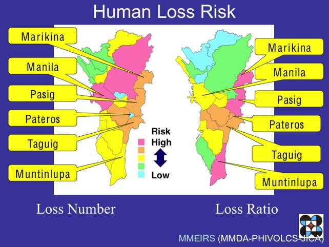
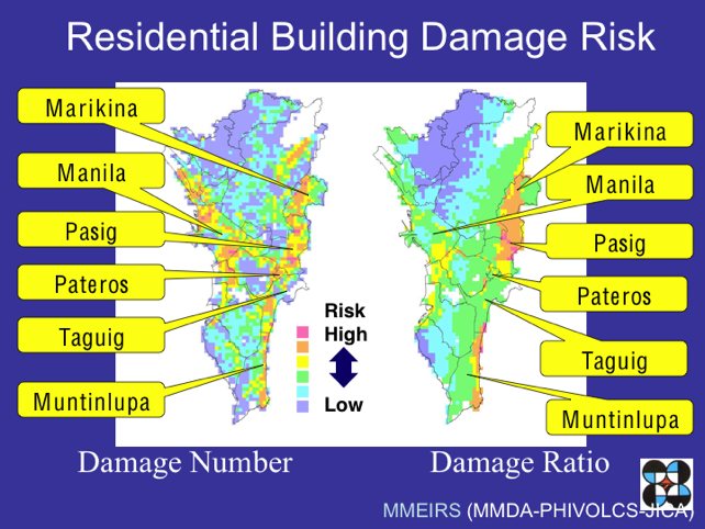
According to the 2004 Metro Manila Earthquake Impact Reduction Study, the West Valley Fault System is entering its active phases which may result in an earthquake of at least magnitude 7. Of the all the cities in Metro Manila, seven are highlighted as being most at risk of heavy damage and casualties in the event of a massive earthquake. These are:
Marikina
Quezon City
Pasig
Makati
Pateros
Taguig
Muntinlupa
Since governmental disaster management systems will be insufficient to cope with the disaster, it's important that each of us take steps now to reduce its impact.
The maps below will help you assess how you could be affected should Manila be hit by a large earthquake. If you live or work in an area highlighted as having a higher risk, it would be wise to take extra precautions.
GMA News fault line map
GMANews.tv has produced an interactive map showing the Valley Fault System together with nearby landmarks. Hovering your mouse over the red fault line will highlight the landmarks within two kilometers of the fault.
MANILA, Philippines – A 5.7 magnitude earthquake jolted cities of Metro Manila early evening today though its epicenter was traced at an island off the coast of Occidental Mindoro, the Philippine Institute of Volcanology and Seismology said.
 Images source: